

#BisingPH
Tropical Depression Bising intensifies, expands wind signal areas
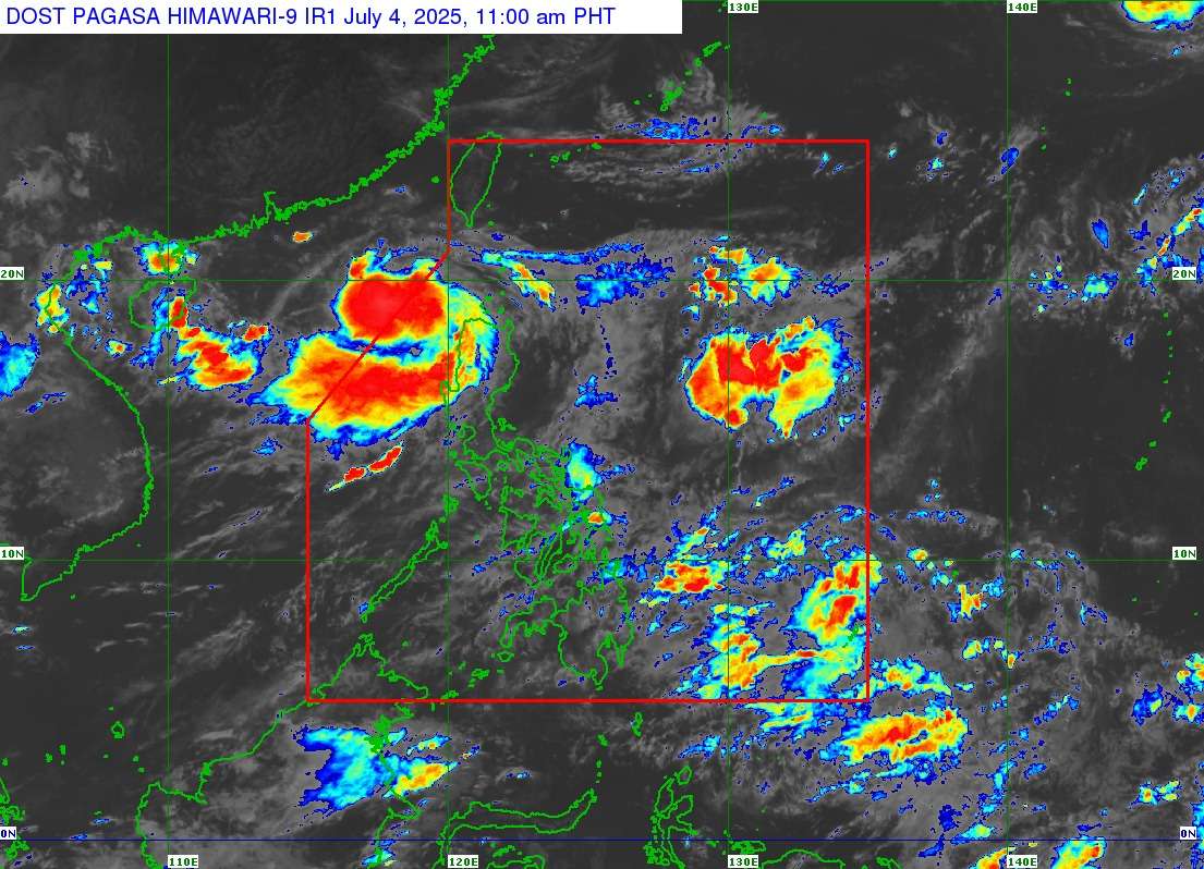
Tropical Depression Bising has slightly intensified as it moves over the sea west of Extreme Northern Luzon, prompting the Philippine Atmospheric, Geophysical and Astronomical Services Administration (PAGASA) to expand the areas under Tropical Cyclone Wind Signal (TCWS) No. 1. This update was issued in PAGASA’s Tropical Cyclone Bulletin No. 2 at 11:00 AM on Friday, July 4, 2025.
As of 10:00 AM, the center of Tropical Depression Bising was estimated at 280 km West Northwest of Calayan, Cagayan (19.3°N, 118.8°E). It now packs maximum sustained winds of 55 km/h near the center, with gustiness of up to 70 km/h, and a central pressure of 1000 hPa. The tropical depression is moving west-southwestward at 15 km/h, and its strong winds extend outwards up to 250 km from the center.
TCWS No. 1 is currently in effect over:
- Western portion of Babuyan Islands: Calayan Island and Dalupiri Island
- Western portion of Ilocos Norte: Pagudpud, Bangui, Burgos, Pasuquin, Dumalneg, Bacarra, Laoag City, Paoay, Currimao, Badoc, Pinili
- Northwestern portion of Ilocos Sur: Caoayan, City of Vigan, Santa Catalina, San Vicente, Santo Domingo, Magsingal, San Juan, Cabugao, Sinait, San Ildefonso
These areas can expect strong winds ranging from 39 to 61 km/h (Beaufort 6 to 7) within 36 hours, posing a minimal to minor threat to life and property. PAGASA warns that local winds may be slightly stronger in coastal and upland/mountainous areas exposed to winds.
Other Hazards and Outlook:
- Heavy Rainfall: The public is advised to refer to Weather Advisory No. 10, issued at 11:00 AM today, for the latest heavy rainfall outlook due to Tropical Depression Bising and the Southwest Monsoon.
- Severe Gusts: The southwest monsoon and the periphery of Bising are expected to bring strong to gale-force gusts over other areas, particularly coastal and upland regions exposed to winds. These include:
- Today (July 4): The rest of Ilocos Norte, Ilocos Sur, La Union, Pangasinan, Isabela, the northern portion of Aurora, Zambales, Occidental Mindoro, Marinduque, Romblon, Palawan, and Antique.
- Tomorrow (July 5): The rest of Ilocos Norte, Ilocos Sur, La Union, Pangasinan, Isabela, the northern portion of Aurora, Zambales, Bataan, Cavite, Oriental Mindoro, Occidental Mindoro, Marinduque, Romblon, Palawan, and Antique.
- Sunday (July 6): The rest of Ilocos Norte, Ilocos Sur, La Union, Pangasinan, Isabela, the northern portion of Aurora, Zambales, Bataan, Metro Manila, Cavite, Oriental Mindoro, Occidental Mindoro, Marinduque, Romblon, Palawan, and Antique.
Coastal Waters:
- Rough seas (up to 3.0 m) are expected over the western seaboards of Babuyan Islands and Ilocos Norte. Small seacrafts, including motorbancas, are advised not to venture out.
- Moderate seas (up to 2.5 m) are expected over the northwestern seaboard of Ilocos Sur.
- Moderate seas (up to 2.0 m) are expected over the seaboard of Batanes, the western seaboards of La Union and Pangasinan, and the remaining seaboard of Ilocos Sur. Mariners of motorbancas and similarly-sized vessels should take precautionary measures.
Track and Intensity Outlook: Tropical Depression Bising is forecast to continue moving generally northwestward slowly in the next 12 hours and may exit the Philippine Area of Responsibility (PAR) this afternoon. It will then turn northeastward over the sea west of Extreme Northern Luzon. Re-entry to the western boundary of the PAR is possible by Sunday morning, with a potential exit from the northern boundary by Monday. PAGASA noted that the forecast track remains highly uncertain, and a possible southward shift, which could lead to TCWS No. 2 being hoisted over Batanes and Babuyan Islands, is not ruled out.
Bising is expected to intensify into a tropical storm by Saturday and may further strengthen as it moves over the sea south of Taiwan.
The public and disaster risk reduction and management offices are advised to take all necessary measures to protect life and property. Residents in areas highly susceptible to these hazards should follow evacuation and other instructions from local officials.