

#BisingPH
Signal no. 1 up as Tropical Depression Bising drenches parts of PH
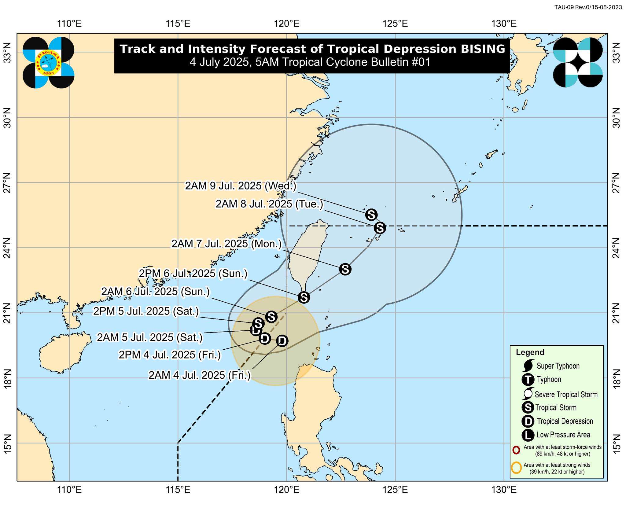
MANILA, Philippines – The low pressure area (LPA) west of Calayan, Cagayan, has intensified into Tropical Depression Bising, the Philippine Atmospheric, Geophysical and Astronomical Services Administration (PAGASA) announced in its first bulletin issued at 5:00 AM on Friday, July 4, 2025.
As of 4:00 AM, the center of Tropical Depression Bising was estimated at 200 km West Northwest of Calayan, Cagayan (19.7°N, 119.6°E). It currently packs maximum sustained winds of 45 km/h near the center and gustiness of up to 55 km/h, with a central pressure of 1002 hPa. The tropical depression is moving southwestward at 20 km/h, and strong winds extend outwards up to 200 km from its center.
Tropical Cyclone Wind Signal (TCWS) No. 1 is now in effect over:
- Western portion of Babuyan Islands: Calayan Island and Dalupiri Island
- Northwestern portion of Ilocos Norte: Pagudpud, Bangui, Burgos, Pasuquin, Dumalneg
Areas under TCWS No. 1 can expect strong winds ranging from 39 to 61 km/h (Beaufort 6 to 7), posing a minimal to minor threat to life and property within a 36-hour warning lead time. PAGASA noted that local winds might be slightly stronger or enhanced in coastal and upland/mountainous areas exposed to winds, while areas sheltered from the prevailing wind direction will experience less strong winds.
Other Hazards Affecting Land Areas:
- Heavy Rainfall: For detailed heavy rainfall outlooks due to Tropical Depression Bising and the Southwest Monsoon, the public is advised to refer to Weather Advisory No. 9 issued at 5:00 AM today.
- Severe Winds: Minimal to minor impacts from strong winds are possible within any of the areas under Wind Signal No. 1.
Hazards Affecting Coastal Waters:
- 24-Hour Sea Condition Outlook:
- Up to rough seas (up to 3.0 m) are expected over the western seaboards of Babuyan Islands. Mariners of small seacrafts, including all types of motorbancas, are advised not to venture out to sea under these conditions, especially if inexperienced or operating ill-equipped vessels.
- Up to moderate seas (up to 2.5 m) are expected over the western seaboard of Ilocos Norte and the northwestern seaboard of Ilocos Sur.
- Up to moderate seas (up to 2.0 m) are expected over the seaboard of Batanes, the western seaboards of La Union and Pangasinan, and the remaining seaboard of Ilocos Sur. Mariners of motorbancas and similarly-sized vessels are advised to take precautionary measures and, if possible, avoid navigation under these conditions.
Track and Intensity Outlook: Tropical Depression Bising is forecast to continue moving generally westward slowly in the next 12 hours and may exit the Philippine Area of Responsibility (PAR) today. Afterwards, it is expected to turn northeastward. Re-entry to the western boundary of the PAR is possible by Sunday (July 6). PAGASA emphasized that the forecast track is highly uncertain, and a possible southward shift, which could result in the hoisting of Wind Signal No. 2 over Batanes and Babuyan Islands, is not ruled out.
Bising is forecast to intensify into a tropical storm by Saturday afternoon or evening and may further intensify as it moves over the sea south of Taiwan.
The public and disaster risk reduction and management offices are advised to take all necessary measures to protect life and property. Residents in areas highly or very highly susceptible to these hazards should follow evacuation and other instructions from local officials. For localized heavy rainfall warnings, thunderstorm/rainfall advisories, and other severe weather information, monitor products issued by your local PAGASA Regional Services Division.