

#CrisingPH
Tropical Depression ‘Crising’ intensifies slightly, wind signal no. 1 hoisted over portions of Luzon
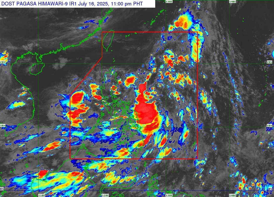
Tropical Depression “Crising” has slightly intensified as it moves northwestward over the sea east of the Bicol Region, prompting the hoisting of Tropical Cyclone Wind Signal (TCWS) No. 1 over several areas in Luzon. The Philippine Atmospheric, Geophysical and Astronomical Services Administration (PAGASA) issued this update in its 11:00 PM bulletin on July 16, 2025.
As of 10:00 PM, the center of Tropical Depression Crising was estimated approximately 615 km East of Virac, Catanduanes, or 630 km east of Juban, Sorsogon. The system now packs maximum sustained winds of 55 km/h near the center, with gustiness of up to 70 km/h, and a central pressure of 1000 hPa. It is currently moving northwestward at a slower pace of 10 km/h. Strong winds extend outwards up to 280 km from the center.
Tropical Cyclone Wind Signal No. 1 is now in effect over:
- Luzon: The southeastern portion of Cagayan (Gattaran, Baggao, Peñablanca), the eastern portion of Isabela (Maconacon, Divilacan, Palanan, Dinapigue, San Pablo, Tumauini, Ilagan City, San Mariano, San Guillermo, Benito Soliven, Echague, Jones, San Agustin, Naguilian, City of Cauayan, Angadanan, Gamu, Cabagan, Reina Mercedes), the northeastern portion of Aurora (Dilasag, Casiguran, Dinalungan), and the northeastern portion of Quirino (Maddela).
These areas can expect strong winds ranging from 39 to 61 km/h (Beaufort 6 to 7), with minimal to minor threat to life and property within a 36-hour warning lead time. PAGASA noted that local winds might be slightly stronger in coastal and upland/mountainous areas exposed to winds. The highest wind signal that may be hoisted during “Crising’s” presence is Wind Signal No. 3.
Other hazards and outlook:
The Southwest Monsoon continues to bring strong to gale-force gusts, particularly in coastal and upland areas exposed to winds. These conditions are expected over:
- Today, July 17: Batangas, Quezon, Bicol Region, MIMAROPA, Visayas, Zamboanga del Norte, Camiguin, Surigao del Norte, Dinagat Islands, Davao Occidental, and Davao Oriental.
- Tomorrow, July 18: Bataan, Metro Manila, CALABARZON, Bicol Region, MIMAROPA, Visayas, Zamboanga Peninsula, Basilan, Sulu, Tawi-Tawi, Misamis Occidental, Lanao del Norte, Camiguin, Surigao del Norte, Dinagat Islands, Davao Occidental, and Davao Oriental.
For coastal waters, up to rough seas (up to 2.5 m) are expected over the western seaboard of Palawan; the northern and eastern seaboards of Catanduanes; the northern and western seaboards of Zamboanga del Norte and Camiguin; the southern seaboards of Negros Oriental, Siquijor, Bohol, and Southern Leyte; the eastern seaboards of Davao Region; and the seaboards of Surigao del Norte and Dinagat Islands. Up to moderate seas (up to 2.0 m) are forecast over the northwestern seaboard of Occidental Mindoro; the southwestern seaboards of Antique and Negros Occidental; and the eastern seaboards of Northern and Eastern Samar. Mariners of motorbancas and similarly-sized vessels are advised to take precautionary measures or avoid venturing out to sea under these conditions.
Track and intensity outlook:
“Crising” is forecast to move generally northwestward over the next 48 hours. It may pass close to or make landfall over mainland Cagayan or Babuyan Islands from Friday evening (July 18) to Saturday (July 19) early morning. Afterwards, it is expected to move west-northwestward and may exit the Philippine Area of Responsibility (PAR) on Saturday afternoon or evening.
“Crising” is forecast to reach Tropical Storm category by the morning of July 17. It is expected to continue intensifying over the Philippine Sea and may reach Severe Tropical Storm category on Friday afternoon or evening, before its approach to Northern Luzon. PAGASA does not rule out further intensification up to Typhoon category prior to its approach.