

#CrisingPH
Tropical Depression ‘Crising’ maintains strength; wind signal no. 1 now up in 9 provinces
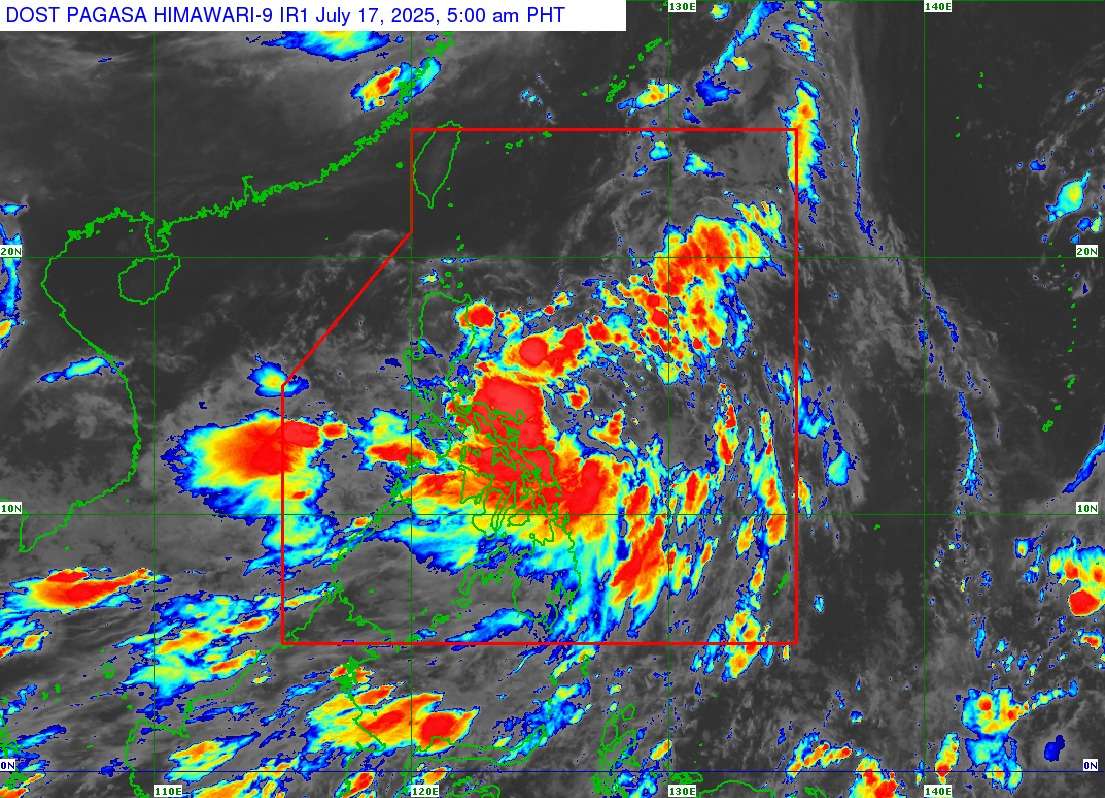
Tropical Depression Crising has maintained its strength while moving west-northwestward over the sea east of the Bicol Region, prompting the expansion of Tropical Cyclone Wind Signal (TCWS) no. 1 to nine provinces across Luzon. This update was issued by the Philippine Atmospheric, Geophysical and Astronomical Services Administration (PAGASA) in its 5:00 AM bulletin on July 17, 2025.
As of 4:00 AM, the center of Crising was estimated approximately 535 km East of Juban, Sorsogon. The tropical depression continues to pack maximum sustained winds of 55 km/h near the center, with gustiness of up to 70 km/h, and a central pressure of 1000 hPa. It is currently moving west-northwestward at 15 km/h, with strong winds extending outwards up to 300 km from its center.
Tropical Cyclone Wind Signal No. 1 is now in effect over:
- Luzon: Cagayan including Babuyan Islands, Isabela, the northeastern portion of Aurora (Dilasag, Casiguran, Dinalungan, Dipaculao), Quirino, Kalinga, the eastern portion of Mountain Province (Sadanga, Barlig, Paracelis, Natonin), the eastern portion of Ifugao (Alfonso Lista, Aguinaldo, Mayoyao, Banaue, Hingyon, Lagawe, Lamut), the northeastern portion of Nueva Vizcaya (Kasibu, Quezon, Bagabag, Diadi), and Apayao.
Areas under TCWS No. 1 can expect strong winds ranging from 39 to 61 km/h (Beaufort 6 to 7) within a 36-hour warning lead time, posing a minimal to minor threat to life and property. PAGASA reminds the public that local winds may be slightly stronger in coastal and upland/mountainous areas exposed to winds, while winds are less strong in areas sheltered from the prevailing wind direction. The highest wind signal that may be hoisted during Crising’s presence is wind signal no. 3.
Other hazards and outlook
PAGASA advises referring to Weather Advisory No. 7, issued at 5:00 AM today, for the heavy rainfall outlook due to Tropical Cyclone “Crising” and the Southwest Monsoon.
The Southwest Monsoon will continue to bring strong to gale-force gusts, especially in coastal and upland areas exposed to winds, over the following areas:
Saturday (July 19): Metro Manila, Central Luzon, CALABARZON, MIMAROPA, Bicol Region, Visayas, Zamboanga Peninsula, Misamis Occidental, Lanao Del Norte, Camiguin, Dinagat Islands, Davao Occidental, and Davao Oriental.
Today (July 17): Batangas, Quezon, Bicol Region, MIMAROPA, Visayas, Zamboanga del Norte, Camiguin, Surigao del Norte, Dinagat Islands, Davao Occidental, Davao Oriental, and Sarangani.
Tomorrow (July 18): Bataan, Metro Manila, CALABARZON, Bicol Region, MIMAROPA, Visayas, Zamboanga Peninsula, Basilan, Sulu, Tawi-Tawi, Misamis Occidental, Lanao del Norte, Camiguin, Surigao del Norte, Dinagat Islands, Davao Occidental, and Davao Oriental.