

#CrisingPH
#CrisingPH exits PAR, intensifies into severe tropical storm
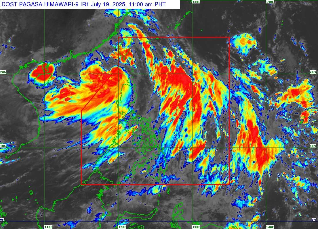
Severe Tropical Storm Crising has officially exited the Philippine Area of Responsibility (PAR) as of 10:00 AM today, July 19, according to the Philippine Atmospheric, Geophysical and Astronomical Services Administration (PAGASA). While the weather system is no longer within the country’s jurisdiction, its effects—enhanced by the Southwest Monsoon—are still being felt across large swaths of Luzon and Visayas.
At the time of exit, Crising was located approximately 235 kilometers west of Itbayat, Batanes (20.6°N, 119.6°E), carrying maximum sustained winds of 100 km/h near the center, gusts of up to 125 km/h, and a central pressure of 980 hPa. The system is currently moving west northwestward at 15 km/h and is expected to continue on this track towards southern China. PAGASA forecasts that Crising may further intensify into a typhoon by tomorrow afternoon or evening.
Wind Signals Still Raised in Northern Luzon
Despite Crising’s exit from PAR, Tropical Cyclone Wind Signals (TCWS) remain in effect in parts of Northern Luzon due to lingering strong winds.
- Signal No. 2 is hoisted over Batanes, the western portion of the Babuyan Islands, and the northwestern part of Ilocos Norte. These areas face gale-force winds (62–88 km/h) within the next 24 hours, with minor to moderate threat to life and property.
- Signal No. 1 is raised over the rest of Ilocos Norte, Ilocos Sur, northern La Union, and portions of the Cordillera and Cagayan Valley regions, where strong winds (39–61 km/h) may occur within 36 hours.
PAGASA warns that local winds may be stronger, especially in coastal and upland areas exposed to prevailing wind directions.
Monsoon-Enhanced Gusts and Rainfall
Crising continues to enhance the Southwest Monsoon (Habagat), bringing strong to gale-force gusts today across the following regions:
- Today (July 19): Metro Manila, Central Luzon, CALABARZON, Bicol Region, MIMAROPA, Visayas, Nueva Ecija, Nueva Vizcaya, Isabela, Benguet, Abra, Zamboanga del Norte, and parts of Northern Mindanao and Caraga.
- Tomorrow (July 20): Most of Luzon and Visayas, including Metro Manila and the Ilocos and Cordillera regions.
- Monday (July 21): Continued monsoon rains and gusts are expected over the same areas.
A heavy rainfall advisory remains in effect. PAGASA urges the public to refer to Weather Advisory No. 16 for specific rain-related hazards.
Storm Surge and Sea Travel Risks
A minimal to moderate risk of life-threatening storm surge remains in place, with peak heights reaching 1.0 to 2.0 meters in low-lying and exposed coastal areas of Batanes, the Babuyan Islands, and Ilocos Norte.
Additionally, a Gale Warning is still up over the northern and western seaboards of Northern Luzon, where sea conditions are classified as very rough, with waves reaching up to 4.5 meters. Sea travel remains risky for all vessels, especially small seacrafts and motorbancas. Mariners are advised to remain in port or seek safe harbor until conditions improve.
Outlook and Public Advisory
Crising is forecast to maintain its west-northwestward direction and intensify as it heads toward southern China. The storm’s wide wind field still extends up to 600 kilometers from its center, contributing to unstable weather in much of Luzon and Visayas despite its departure from PAR.
PAGASA reminds local government units, disaster risk reduction agencies, and the public to remain vigilant. Those in areas highly susceptible to floods, landslides, and coastal inundation should follow all safety advisories and evacuation orders issued by local authorities.