

#BisingPH
Tropical Depression Bising intensifies into a tropical storm, remains outside PAR
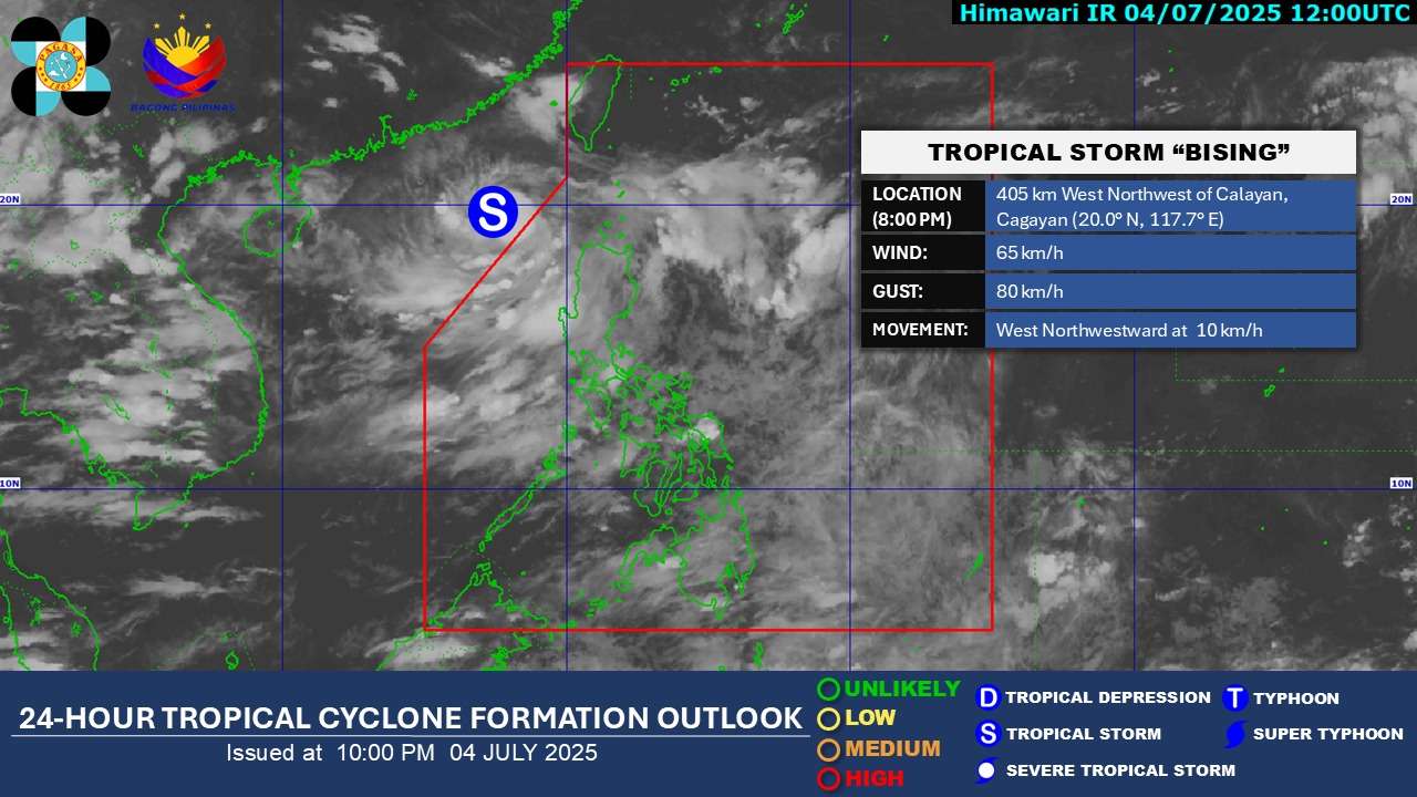
MANILA, Philippines – Tropical Depression “Bising” has intensified into a tropical storm as of 8:00 PM today, July 4, 2025, according to the latest advisory from the Philippine Atmospheric, Geophysical and Astronomical Services Administration (PAGASA). While the storm remains outside the Philippine Area of Responsibility (PAR), its trough and the Southwest Monsoon are expected to bring significant rainfall and rough sea conditions to parts of Luzon.
As of 10:00 PM, the center of Tropical Storm Bising was estimated at 415 km West Northwest of Calayan, Cagayan, or 460 km West of Basco, Batanes (20.1°N, 117.6°E). It now packs maximum sustained winds of 65 km/h near the center and gusts of up to 80 km/h, with a central pressure of 998 hPa. The storm is moving west-northwestward at 10 km/h, with strong winds extending outwards up to 250 km from its center.
Heavy rainfall outlook
PAGASA’s Weather Advisory No. 12, issued at 11:00 PM today, details the heavy rainfall outlook:
- Tonight to tomorrow evening (July 5): 50-100 mm of rain is expected over Ilocos Norte and Batanes due to the trough of the tropical cyclone.
- Tomorrow evening to Sunday evening (July 6): 50-100 mm of rain is expected over Batanes due to the trough.
- Tonight to tomorrow evening (July 5): 50-100 mm of rain is expected over Ilocos Sur due to the Southwest Monsoon.
- Tomorrow evening to Sunday evening (July 6): 50-100 mm of rain is expected over Ilocos Norte and Ilocos Sur due to the Southwest Monsoon.
PAGASA warns that rainfall may be higher in mountainous and elevated areas, and impacts could be exacerbated by significant prior rainfall.
Sea condition outlook (24 Hours)
- Rough seas (up to 3.0 m) are expected over the western seaboards of Babuyan Islands and Ilocos Norte. Mariners of small seacrafts, including motorbancas, are advised not to venture out.
- Moderate seas (up to 2.5 m) are expected over the northwestern seaboard of Ilocos Sur and the seaboard of Batanes.
- Moderate seas (up to 2.0 m) are expected over the western seaboards of La Union and Pangasinan, and the remaining seaboard of Ilocos Sur. Mariners of motorbancas and similarly-sized vessels should take precautionary measures.
Track and intensity outlook
Tropical Storm Bising is forecast to move north-northwestward tonight through tomorrow morning before turning north-northeastward over the sea west of Extreme Northern Luzon. Re-entry to the western boundary of the PAR is possible by Monday (July 7) early morning, with a potential exit from the northern boundary of PAR on Monday afternoon. PAGASA notes that Bising intensified into a Tropical Storm at 8:00 PM today, and further intensification is possible, with the storm potentially reaching severe tropical storm category by Sunday (July 6).